Last Sunday, we went on a spectacular Sunday drive on the Apache Trail, in the southeast Phoenix area. Originally the trail the Apache Indians used to get through the Superstition Mountains, it was also a stagecoach trail back in the day. It is now partly paved, with 28 miles (of 40) still a dirt road through the mountains. For more information, click
here. The trail has several interesting stops along the way, including Goldfield (an old mining town-now a tourist attraction), Lost Dutchman State Park (good hiking), Canyon Lake and Tortilla Flat (a very small town). After that, the road turns to dirt, and becomes a white-knuckler, winding through the mountains with steep drop offs on this one and a half lane road. The road eventually leads to Roosevelt Dam, which is very important for the water needed in Phoenix! I knew I couldn't handle this road well, so after reading and researching, we planned
on turning around when the pavement ended and taking the circle route from Apache Junction, through Globe to Roosevelt Dam and Tonto National Monument, and then continuing on to Phoenix. We spent the entire day on the road...leaving by 8:30 and returning at 6, just as it got dark. The sights were just beautiful. Imagining living and traveling through this area back in the day....as an Apache Indian or via stagecoach....was mind-boggling.

 |
| beginning of Apache Trail closest to Apache Junction |
There were several areas of interest along the way, such as Lost Dutchman Museum, Goldfield Ghost Town, Lost Dutchman State Park, but except for a few very short stops we continued on to Tortilla Flat and decided to visit some of the stops on our return ride. We stopped briefly at an overlook for Weaver's Needle, and again at a viewpoint for Canyon Lake. The drive was amazing!
 |
| Weaver's Needle in the distance |
 |
| beautiful colors all around (its FREEZING!) |
 |
| seems everywhere we looked on this beautiful drive, there were also power lines! |
 |
| looks like a stage set for a wild west movie |
 |
| every turn brings another great view |
 |
| our first stop was the Canyon Lake Vista...the first glimpse we got of the lake |
 |
| just beautiful...surrounded by mountains. A very popular water sports area |
 |
| serene, isn't it? |
 |
| did I mention how cold and windy it is? (We thought it was supposed to be 75 today, not 45!) |
 |
| approaching Canyon Lake |
We stopped at Tortilla Flat, a very small town of 6, and had the best ice cream. Even though it was just mid-morning and still pretty cold, we were ready! We had such a beautiful clear day, which we took advantage of. The week ahead was forecast to be rainy and cold, with snow in the mountains, so we decided it would be best to go on this little adventure while we could!
 |
| Tortilla Flat....an actual town with 6 citizens |
 |
| anything you need is right here...restaurant, bathroom, shopping, ice cream |
 |
| good sense of humor...no worries....another bathroom in the restaurant |
 |
| checking things out...this restaurant looked really good but it was too early for lunch and we had our picnic with us |
 |
| Howdy Pardner |
 |
| Never mind the hangman.....does that say ice cream? |
 |
| we heard the prickly pear ice cream was not to be missed...so we had it even though it was about 10 in the morning! (and freezing) |
 |
| lots of stuff to look at |
 |
| check out the wall paper...I think they are real dollar bills |
 |
| they are everywhere |
 |
| lots of law enforcement passed through here too!....I see Roxbury Twp, NJ, about 20 minutes from our former home! |
 |
| great ice cream! |
 |
| I normally don't take pictures in the bathroom, but no one was in here....check this out! |
 |
| too funny |
 |
| we by-passed the small museum trying to pace ourselves on this loop of a road trip |
After our pit stop, we traveled just a couple more miles before the road turned to dirt. There was a sign warning that the pavement would end, and if you aren't ready to take the 28 mile drive down the dirt road, it is a good place to turn around. The drive back to Apache Junction was just as beautiful, with different viewpoints. This section of the Apache Trail, though not as "exciting" as the description of the last 28 miles on the dirt road, offers quite a lot of interest as well. There are switchbacks, winding sections with steep drop offs, and of course steep grades. The views are just amazing, but the driver really has to pay attention. We stopped at a few pullouts so Tom could enjoy the view too! (Yes I feel guilty!)
 |
| don't want to be driving around here in the dark! |
 |
| we turned around in the last pullout available on the paved road |
 |
| the view is so different heading back to Apache Junction |
 |
| the road is not at all boring..it has lots of twists and turns, and steep drop off's to keep your heart pumping |
 |
| the views are spectacular, no matter where you look |
 |
| can you see part of the road down there? |
 |
| incredible colors |
 |
| of course, a steep drop off past this rock behind me |
 |
| you can see the dirt road from here....28 miles of thrilling, white knuckle driving (from what we hear) |
 |
| another nice view at a scenic turnout |
 |
| stay away from the edge though...very steep drop off |
We had a lot of road to cover before dark (didn't want to be driving these roads in the dark!), so we briefly stopped at Goldfield's and took a look around. We didn't stop at the Lost Dutchman State Park, since we knew we didn't have time for a hike, but rather headed out on the circle route around and through the Superstition Mountains. What a ride!
 |
| Goldfield's Mining Town |
 |
| classic shot of the Superstition Mountains |
 |
| a re-created village - looks like a fun family day can be spent here (bring your wallet) |
 |
| mining tours are available |
 |
| lots of shops, a restaurant, a brothel and a church |
 |
| dressed in character |
 |
| you could be entertained here all day...but we were on a tight schedule |
 |
| cool looking house (the brothel) |
 |
| a popular spot...the saloon |
 |
| real church was just getting out of the service, so we didn't go in |
 |
| lots and lots of stuff to do here |
 |
| the mountains were calling us though |
 |
| cool shop |
We traveled along Rt. 60 through Superior and Miami (beautiful drive), on to Globe, where we picked up Rt. 188 leading to Roosevelt Lake. From there, we traveled until we hit Rt 87 heading back to Phoenix. There were many places of interest along this route, such as the Boyce Thompson Arboretum, but again, we picked our stops based on our time constraints.
In my research, it was suggested to overnight in Miami or Globe if you intend to spend more time exploring. There really aren't all that many options. Not a bad idea if you want to spend time at most of the attractions-otherwise you really need to pick and chose what you want to visit.
 |
| driving towards Globe |
 |
| how un-nerving is that? |
 |
| the views here were also spectacular |
 |
| we drove through a few little towns |
 |
| interesting drive |
 |
| tunnels |
 |
| hills |
 |
| beauty all around |
 |
| bridges |
 |
| winding roads |
 |
| steep drops |
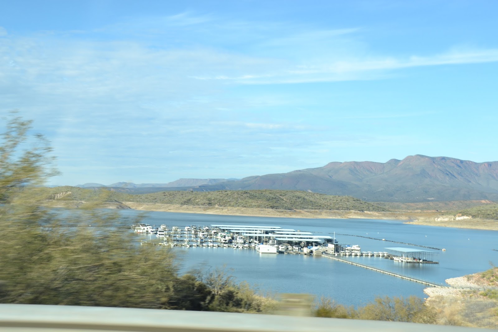
The two places we really wanted to visit were Roosevelt Dam and Tonto National Monument. Roosevelt Lake was gorgeous, especially the colors in the mid-afternoon sun. After our late afternoon picnic lunch overlooking Lake Roosevelt, we headed first to Tonto, since we came upon it first.
 |
| we made it...Roosevelt Lake ahead |
 |
| the colors were fantastic |
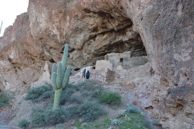
Nearby, the Tonto National Monument was open and we took advantage of the Visitor Center and the walk up to the Cliff Dwellings. For more information, click
here. If it looks like you have to walk up the side of the mountain to see the dwellings, well, you are right! The paved path has many switchbacks with steep drop offs. Yikes! The path is wide though, so its not as bad as it could be. We met a young woman wearing an LBI sweatshirt (extrememly popular in NJ) so we stopped a minute to chat. Yes, she was from Long Beach Island, NJ...and she was even more terrified of heights than I was. She ditched her boyfriend and was carefully making her way back when we met her. What a small world it is.
 |
| the view from the Visitor's Center |
 |
| the Cliff Dwelling is right above the Visitor Center |
 |
| a close up |
 |
| heading up to the cliff dwelling ... lots of switchbacks...and the blinding sun so I didn't see the drop offs |
 |
| glad I put on my sneakers for this |
 |
| another view... |
 |
| lots of steep drop offs but the path is wide and paved |
 |
| oh, and steep! Catching our breath |
 |
| almost there |
These Salado Cliff Dwellings are about 700 years old, and are a bit different than some of the other cliff dwellings we've visited in the desert southwest. There are two cliff dwellings here, and we went to the lower one. The Upper Cliff Dwelling is by guided tour only, and lasts 3-4 hours. The trail to the Lower Cliff Dwelling is 1/2 mile UP. It is entirely switchbacks, with a few stairs at the end, and takes about 20 minutes or so to get up there.
 |
| not too far now |
 |
| imagine getting here without the paved path! |
 |
| this was the entrance...there was a ladder up there too |
 |
| this is right at the side of the mountain |
 |
| going back down was not easy for me |
 |
| always the question! |
 |
| this is one of the rooms...the "fireplace" is behind me to the right |
 |
| another room...protected from vandals by a fence |
 |
| the view out from one of the rooms |
 |
| lots of storage here |
 |
| another view....not too much room up there to take pictures....too close |
 |
| There you have it ....Tonto National Monument |
 |
| the cliff dwellings are right up there |
Next stop....Roosevelt Lake/Dam. We wanted to learn a little more about the Dam and its importance to the water supply for Phoenix, but unfortunately the Visitor Center was closed on Sundays! As we drove down to the Visitor Center at Roosevelt Lake, we were wondering why the parking lot was so empty. Oh well. At least we were able to enjoy the views of the lake! The scenery was just terrific as we headed back to Phoenix. What a beautiful day!!
 |
| Roosevelt Lake/Dam |
 |
| some nice boats there! |
 |
| Roosevelt Bridge |
 |
| the Visitor Center was closed on Sundays |
 |
| beautiful...with the reflections |
 |
| the colors were great in this field leading up to the mountains (part of the lake dried up) |
 |
| great colors |
 |
| a very scenic drive heading back to Phoenix |
 |
| thank you for cutting through the mountain! |
 |
| Phoenix area |
 |
| sunset time |


No comments:
Post a Comment